When you’re in a foreign country, you don’t question signs as much as you might have if you were at home. You’re just so happy to see a sign that makes sense, that you follow it.
I don’t know if there was anything that should have made us second guess our course, but if there was it might have been wise for us to pay attention to it.
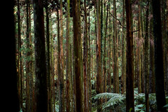
The path was very easy at first, and visually stunning. The paved pedestrian only road ran along a ridge in a huge cedar forest. The trees bases were far below us but they were so tall that we were still under their shady canopy.
Water poured and dripped from the side of the path, sending thin streams across the path and down the ridge. Everything smelled mossy and fresh.
The incline was a bit steeper than expected, but not a big deal since the path was so easy to walk on. Pictures online made it seem like a flat trail, but the mention of “mountain huts”, one of which we planned to sleep in that night, hinted that it may not be that simple.
After a little while the paved road ended abruptly and turned into a dirt road.
We were all happy about this since we were out there to enjoy nature, and being rid of the pavement made the experience a lot more authentic.
And then the dirt road ended.
In front of us was a narrow, sometimes non existent trail, marked by pink ribbons tied around trees every five to ten meters.
Surprisingly, the route also became more steep. This was surprising to me because I distinctly remember the trail being billed as “not strenuous” on the web site.
We saved our GPS location on our watches to counter the now-realistic possibility that we could end up in the middle of the forest with no bearings.
The forest was immeasurably beautiful in a way that my pictures just can’t capture. They show a small slice, but the experience of being totally surrounded by and ancient forest an a tiny island in the Pacific Sea is amazing.
Our path roughly followed a large stream that ran from the top of the mountain down to the bottom by way of a series of waterfalls. Whenever we’d stop to rest and refill our water bottles in the crystal clear stream, we’d all gaze around in every direction to marvel at the majesty of the forest.
Humans have created incredible things, but nothing takes your breath away more than the massively scaled creations of nature.
As we progressed up the hill the terrain became more and more challenging. While scurrying from one pink ribbon to the next we were now frequently climbing steep inclines, walking an loose slippery rocks, and using trees to steady ourselves.
According to a site I read it was supposed to take us one to two hours to get to the mountain hut. We’d been out there for at least three or four and hadn’t seen any signs of a hut.
After a while we fell in to the pattern of assuming a mountain hut was around every corner.
“Is that it?”
No.
It began to get dark, something which happens more quickly in the forest because it’s so shady. Given the erratic terrain, this was going to be a problem if we didn’t get to the hut quickly.
Finally, through the dusk, we spotted a sign at the top of a dried out streambed. We hurried up it, sure that we were right next to the hut.
But we weren’t. In fact, the hut was 2.3 kilometers away from us. What in the world had happened?
Now lighting the map with a flashlight we analyzed it and tried to figure out what had happened.
Finally it clicked.
We weren’t on the sanctioned trail, but rather an unmaintained mountain path intended for the backcountry types.
in fact, we were now within striking distance from the beginning of the trail that we were supposed to have taken in the first place.
It was nighttime now, and by the time we made our way to the beginning of that path we realized that we weren’t anywhere near a suitable place to sleep.
And so we did what any reasonable adventurers would do. We set up camp on the roof of the bathrooms, and once again slept on a hard and inhospitable surface, determined to finally make it to the mountain huts the next day.


Leave a Reply